


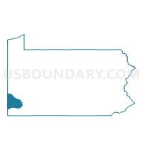
INDEPENDENCE TWP VTD 01, Washington County, Pennsylvania
About
Outline

Summary
| Unique Area Identifier | 664258 |
| Name | INDEPENDENCE TWP VTD 01 |
| County | Washington County |
| State | Pennsylvania |
| Area (square miles) | 20.92 |
| Land Area (square miles) | 20.91 |
| Water Area (square miles) | 0.01 |
| % of Land Area | 99.93 |
| % of Water Area | 0.07 |
| Latitude of the Internal Point | 40.22684600 |
| Longtitude of the Internal Point | -80.48702520 |
Maps


Graphs
Select a template below for downloading or customizing gragh for INDEPENDENCE TWP VTD 01, Washington County, Pennsylvania


Neighbors
Neighoring Voting District (by Name) Neighboring Voting District on the Map
- Voting District 14, Brooke County, WV
- Voting District 21B, Brooke County, WV
- BLAINE TWP Voting District, Washington County, PA
- DONEGAL TWP VTD 02, Washington County, PA
- HOPEWELL TWP Voting District, Washington County, PA
- INDEPENDENCE TWP VTD 02, Washington County, PA
- JEFFERSON TWP Voting District, Washington County, PA
Top 10 Neighboring County Subdivision (by Population) Neighboring County Subdivision on the Map
- Wellsburg district, Brooke County, WV (8,304)
- Donegal township, Washington County, PA (2,465)
- Independence township, Washington County, PA (1,557)
- Jefferson township, Washington County, PA (1,162)
- Hopewell township, Washington County, PA (957)
- Blaine township, Washington County, PA (690)
Top 10 Neighboring Unified School District (by Population) Neighboring Unified School District on the Map
- Brooke County School District, WV (24,069)
- McGuffey School District, PA (12,757)
- Burgettstown Area School District, PA (9,699)
- Avella Area School District, PA (4,209)
Top 10 Neighboring State Legislative District Lower Chamber (by Population) Neighboring State Legislative District Lower Chamber on the Map
- State House District 46, PA (62,516)
- State House District 49, PA (58,268)
- State House District 2, WV (34,538)
Top 10 Neighboring State Legislative District Upper Chamber (by Population) Neighboring State Legislative District Upper Chamber on the Map
Top 10 Neighboring 111th Congressional District (by Population) Neighboring 111th Congressional District on the Map
Top 10 Neighboring Census Tract (by Population) Neighboring Census Tract on the Map
- Census Tract 7310, Washington County, PA (6,053)
- Census Tract 7210, Washington County, PA (4,209)
- Census Tract 316, Brooke County, WV (3,875)
- Census Tract 7110, Washington County, PA (3,835)